Active Travel Strategy 2023-30 : Evidence Report C
Network Connectivity Assessment – November 2022
Introduction
This network connectivity assessment considers map-based evidence to explore the following questions and inform the Active Travel Strategy:
- Where are East Dunbartonshire’s key trip generators and how are these connected?
- Which areas of East Dunbartonshire lack connection?
Policy Context
National planning and transport policy emphasise ease of access to important local services to promote sustainable transport and help foster cohesive communities. Scotland’s fourth National Planning Framework (NPF4) underlines the importance of local living within a neighbourhood that forms part of a wider network of neighbourhoods in which local services are accessible within a ten-minute walk of people’s homes (approximately 800m). NPF4 understands the concept will be interpreted differently in urban, suburban and rural places but the fundamental principle of living locally and using sustainable transport where possible remains constant.
Transport Scotland’s Strategic Transport Projects Review (STPR) 2 proposes active travel infrastructure to create connected neighbourhoods. This infrastructure will cut carbon emissions, reduce inequalities in access to services, jobs and leisure, create pleasant communities, improve health and support sustainable economic growth. The three STPR2 theme A recommendations relevant to connectivity in East Dunbartonshire are village-town active travel connections, connecting towns by active travel and expansion of the long-distance active travel network.
The Transport Scotland / CoSLA target of a 20% reduction in total car kilometres in Scotland by 2030 supports the notion that people’s places and transport choices should enable everybody to be able to access most of what they need and want locally.
Strathclyde Partnership for Transport (SPT) has proposed a regional active travel network as part of its 2022 Regional Transport Strategy. This network aims to connect all settlements over a certain size (including East Dunbartonshire’s major towns) to one another by high-quality active travel routes.
Network Connectivity Assessment Mapping
To understand how the current active travel network connects people to the places they want to go, the network was mapped alongside several key trip generators, listed below:
- Public transport: train stations, bus stops
- Local employment sites – Local Development Plan business sites
- Town and village centres and supermarkets
- Green space
- Primary and Secondary Schools
- Health services (GPs)
- Leisure centres
Local Connectivity
Active Travel Maps
The following maps are divided into areas of East Dunbartonshire showing off-road active travel routes, cycle routes (the Bears Way and Wester Way) and key trip generators (as outlined above).These maps aim to illustrate where active travel infrastructure could best serve communities by connecting the places people want and need to go. Updates may be made to this mapping over time to reflect updated information or local changes.
The following legend applies to all the maps in this Local Connectivity section.
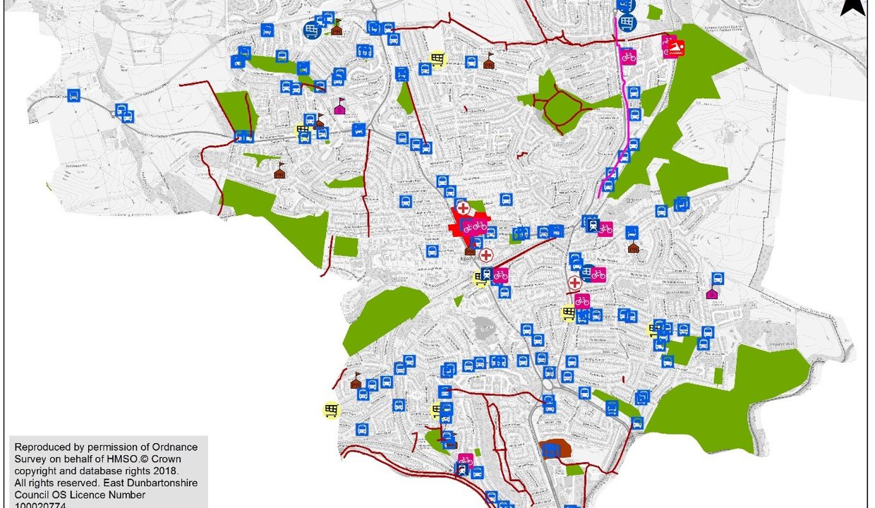
Bearsden
This map shows active travel routes, public transport and key trip generators in Bearsden. The map shows the value of extending the Bears Way north to Milngavie town centre and south to Hillfoot station/amenities with a view to a further extension towards more trip generators (shops, health centre, green space) along the route as it approaches the boundary with Glasgow City Council (GCC). A generalisation that can be made from the map of Bearsden is that schools are poorly connected and active travel routes are required to make students and parents feel that active travel is a safe and convenient option for school travel. The only current active travel route connecting Bearsden town centre (Jubilee Path) is unlit and stepped, making it inadequate for use during night time and for cycling and wheeling. The town centre lacks active travel connection in all directions.
As well as the Bears Way, there are other opportunities to connect the Bearsden area to Milngavie to the north. Off-road paths could be connected to link Bearsden and Milngavie via St Germains Loch and enhance the green active travel network.
Although Bearsden’s area is large, there is an even spread of amenities (schools, shops and public transport) across the area. Active travel infrastructure should focus on connecting these amenities to promote modal shift of everyday trips to active, sustainable transport.
Some greenspaces are better served by the active travel network than others. Colquhoun Park has particularly poor connections and is located close to where Glasgow City Council are proposing high-quality cycling infrastructure. This presents an opportunity to link Bearsden town centre to green space and a nearby school.
Bishopbriggs
This map shows active travel routes, public transport and key trip generators in Bishopbriggs. The map shows a network of off-road paths for recreational active travel outside the limits of Bishopbriggs built environment. Residential areas in all directions from Bishopbriggs town centre are poorly served by active travel infrastructure. Notably, Bishopbriggs schools are poorly connected to the existing active travel network. The large, forthcoming developments at Westerhill (a large site to the northeast of the town centre) will require active travel connections to Bishopbriggs town centre and station. Auchinairn (southern and eastern boundary of the map) is one of East Dunbartonshire’s four locality areas identified as experiencing inequality and deprivation and its active travel connections to surrounding amenities require improvement as well as its footways (see Report B). Current connections between the Bishopbriggs area and Glasgow are off-road, unlit and indirect. While Bishopbriggs is well-served by rail and bus, Auchinairn has less reliable connections to Glasgow and active travel provisions would provide economic, social and health benefits.
From the above map of existing routes, a loop route incorporating existing infrastructure (canal towpath and Wester Way cycle route) and new infrastructure to connect residential areas to Bishopbriggs town centre appears feasible and logical. This loop could link Auchinairn to St. Helen’s Primary, Thomas Muir Primary and Bishopbriggs Academy in the east of Bishopbriggs as well as Bishopbriggs town centre. This loop could also connect residential areas to Bishopbriggs’ north to the Leisuredrome, the canal and town centre amenities. A loop route is suitable for Bishopbriggs due to the position of Bishopbriggs town centre in relation to Auchinairn and other surrounding residential areas, potential developments in Westerhill and along the A803 corridor and existing active travel infrastructure along the canal.
Residential areas west of Bishopbriggs are near town centre amenities and active travel neighbourhood interventions such as high-quality footways and traffic calming in that area would promote active travel as the logical choice for everyday journeys to the town centre.
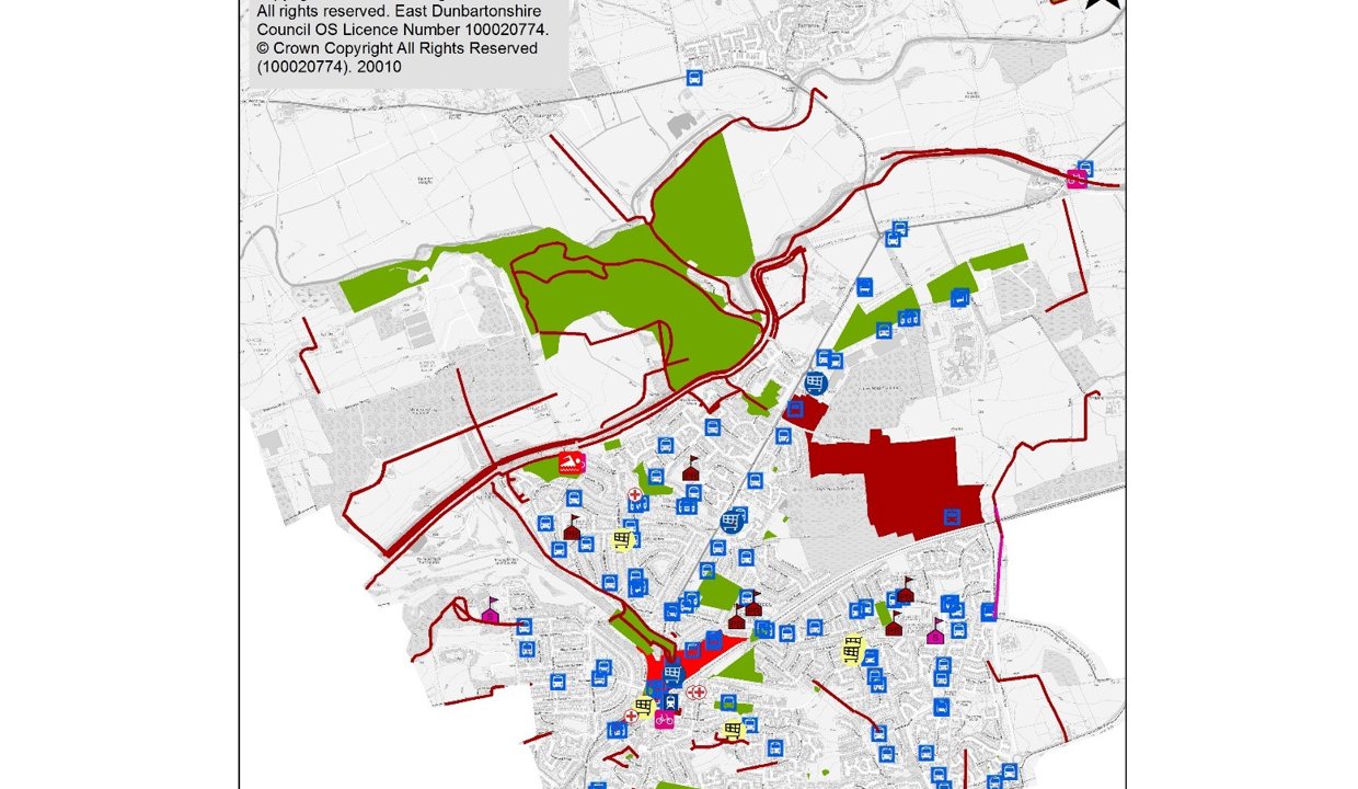
Kirkintilloch, Lenzie and Twechar
The map shows active travel routes, public transport and key trip generators in Kirkintilloch, Lenzie and Twechar. The canal and Strathkelvin Railway Path provide good east-west and north-south routes for active travel, however, a lack of lighting and, in some places, poor surfaces and a lack of width, means the paths are not perceived as options at night and some users are excluded. Without these paths, there are no significant active travel routes connecting residential areas to town centres and public transport in the area. The schools in the area could be better connected to an active travel network. The three schools in Hillhead and Harestanes lack active travel links. Hillhead, a locality area, requires better connections to central Kirkintilloch.
Lenzie station and its surrounding amenities are missing potentially beneficial connections to surrounding residential areas and Kirkintilloch. A route connecting Lenzie station and Kirkintilloch would be particularly useful to enable easier journeys between Kirkintilloch town centre, Bishopbriggs, Glasgow and Edinburgh by train.
Besides the canal path, which due to being unlit is not well-used in hours of darkness, there is no active travel connection between residential areas to the west of Kirkintilloch and the town centre.
Lennoxtown, Milton of Campsie and Clachan of Campsie
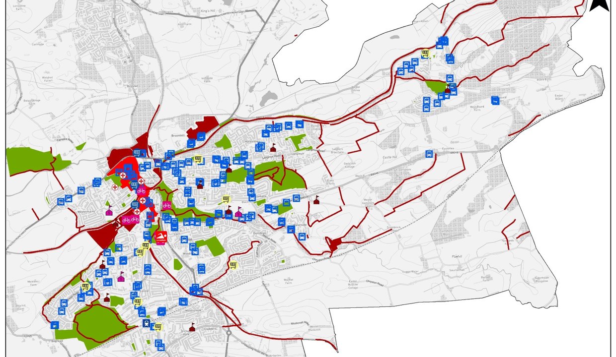
This map shows active travel routes, public transport and key trip generators in Lennoxtown and its surrounds. Lennoxtown has a good quality active travel route (Strathkelvin Railway Path), which runs east-west, south of the town centre but there is no connection between the town centre and the path. Furthermore, this path is rural and unlit meaning it is used minimally during hours of darkness. Lennoxtown Primary School (to the north of the town centre) is close to town centre amenities, and has good access to greenspace but lacks active travel connections. Lennoxtown is a locality area and active travel connections between residential areas and town centre shops, transport and the Hub are necessary to tackle inequality. Active travel routes in Milton-of-Campsie fail to connect residential areas with the village’s amenities: education, shops and public transport. The area-wide issue of an active travel network geared towards trips for leisure is more noticeable in this rural part of East Dunbartonshire, an active travel network which connects everyday places of interest such as schools, shops and public transport is necessary.

Milngavie
This map shows active travel routes, public transport and key trip generators in Milngavie. Milngavie town centre appears to have reasonable north-south active travel connections although the West Highland Way to the north and the path to the south are off-road, unlit and therefore not conducive to promoting active travel during hours of darkness. Shops and schools to the west of the town centre lack connection to surrounding residential areas and the town centre. There are a lack of routes south of the town centre and a gap in the network between the town centre and the start of the Bears Way cycleway which starts below the southern boundary of this map.
Milngavie, due to the West Highland Way, the reservoirs and Mugdock Country Park, is a destination for visitors. These trip generators and green spaces could be better connected to the town centre and public transport.
Torrance, Balmore and Bardowie
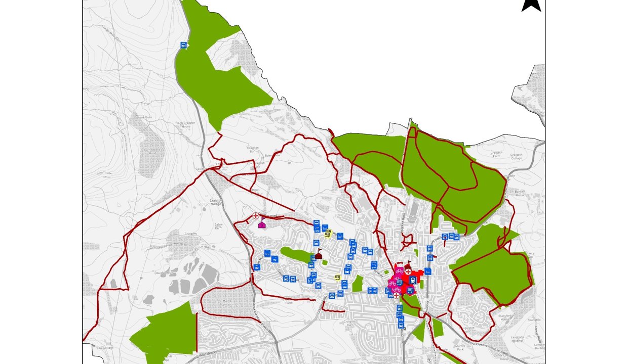
The above map shows active travel routes, public transport and key trip generators in Torrance, Balmore and Bardowie. Parts of this area are rural and remote and many of these paths are inaccessible for cycling and wheeling. The off-road active travel routes in this area largely run north-south and fail to provide an alternative to the A807, a fast, narrow road connecting Torrance, Balmore and Bardowie to other areas of East Dunbartonshire. A safe alternative to using the A807 for active travel would improve prospects for active travel in the area, and, as seen in green network and regional active travel connectivity maps (pg. 15-16), is a strategically important route.
The off-road active travel network in Torrance (to the west of the map), on the other hand, provides a strong foundation for a walking network. Torrance Primary School, town centre shops and public transport are served by the current network although the network audit (Report B) flagged some issues which constrain the network’s accessibility. Rather than prioritising access to remote bus stops in the centre and east of the map through new active travel routes, it would be more beneficial to improve the quality of pedestrian environments around these bus stops, as well as the amenities at the bus stops themselves, to make the mode more attractive for the user. This is because routes mostly already exist, new routes would serve few people and, finally, several submissions to the Ideas Map (Report G) related to environments around bus stops in this area including nearby crossings. Notwithstanding, the network audit should inform the maintenance of the extensive off-road network in this area, which is important for residents and visitors and contributes to improved health and well-being.

Regional connections
Strathclyde Partnership for Transport’s Regional Active Travel Network

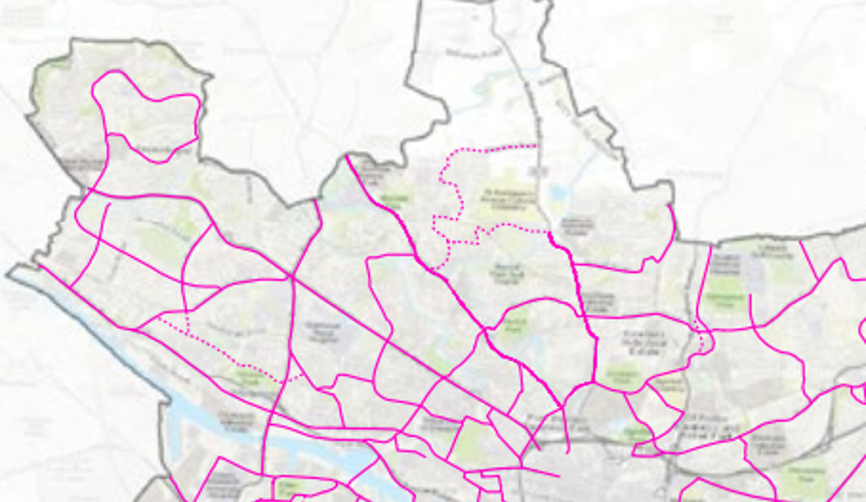
The SPT Regional Active Travel Network presents a vision for comprehensive regional active travel connectivity. It includes primary strategic routes (connecting Bearsden and Bishopbriggs with Glasgow as well as northeast towards Kilsyth), orbital routes (connecting Bearsden with Bishopbriggs and Milngavie with Torrance and Kirkintilloch and cross-regional routes (connecting Milngavie to Strathblane). Also included are links from Kirkintilloch and Bishopbriggs to North Lanarkshire and Milngavie and Bearsden to West Dunbartonshire.
Legend (selected towns on map)
| 37 | Milngavie | 49 | Faifley |
|---|---|---|---|
|
38 |
Bishopbriggs |
46 |
Lennoxtown |
|
36 |
Bearsden |
47 |
Milton of Campsie |
|
39 |
Kirkintilloch |
45 |
Torrance |

The map focuses on the proposed regional active travel links in East Dunbartonshire. At this scale, it is clear how this regional strategy ties in with Glasgow’s proposed city network, as routes from Glasgow to Bearsden and Bishopbriggs are marked in blue as primary strategy routes. Routes north of
his map has been published in SPT’s Draft Regional Transport Strategy 2022-2037; the map has been cropped to show the northern half of the region.
Milngavie and connecting Milngavie/Bearsden to Torrance/Bishopbriggs would be useful both to complete an East Dunbartonshire loop route (ATS 2015-2020) and to contribute to SPT’s regional network.
Strategic Access Blueprint: Regional Green Network


Cross-Boundary Routes
Bearsden
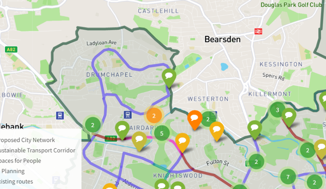
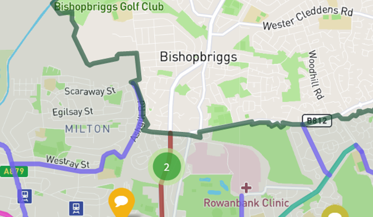
The map is from a 2021 consultation on GCC’s forthcoming Active Travel Strategy. Light blue routes (proposed city network) are segregated cycleways while red routes are sustainable transport corridors. The proposed routes give a sense of the scale of Glasgow’s commitment to delivering a comprehensive network of segregated cycling infrastructure. There are two points at which the Glasgow network will meet the boundary of East Dunbartonshire (Bearsden Road and the A81) and one point where the proposed city network comes within a few metres of the boundary (Canniesburn Road).Ensuring that active travel networks continue across Council borders and connect the places people want to go is critical for the success of promoting active travel.
Bishopbriggs and Auchinairn

Other cross-boundary connections
It is important to consider East Dunbartonshire’s other boundaries and active travel’s role in facilitating cross-boundary trips. Due to the rural nature of all of East Dunbartonshire’s boundaries (except its southern boundaries with GCC), most cross-boundary active travel trips will be for leisure. The canal towpath is a good quality route into Glasgow to the south, North Lanarkshire and Edinburgh to the west, the West Highland Way is a well-used route northwards and the Clyde Coastal Path is a marked trail to West Dunbartonshire. Furthermore, an action from the first Active Travel Strategy 2015 proposed an East Dunbartonshire loop route which would incorporate an active travel route from the Strathkelvin Railway Path near Strathblane, through Stirling Council area south to Milngavie.
Mugdock Country Park is currently owned and managed by East Dunbartonshire and Stirling Councils. A popular place amongst tourists and visitors, the ATS must consider how to better connect Mugdock Park to an active travel network. Currently, off-road paths offer an indirect route while on-road footways are narrow, inaccessible and close to fast-moving traffic. There has been consultation on a draft Mugdock Strategy 2022-2027 and the strategy is due to be presented to committee in December. The draft strategy includes actions and projects to improve Mugdock Park’s connectivity:
- Standardised signage clarifying pedestrian routes to the park
- Strong links to Milngavie town centre; e-bike connection to Milngavie rail station; clear connection to West Highland Way; explore opportunity for seasonal low emission bus connection to ease car parking pressure; maximise overall benefits in proximity
- Improve connection to wider green network and town centre (West Highland Way, Allander Water, Reservoirs)
Pavement widths
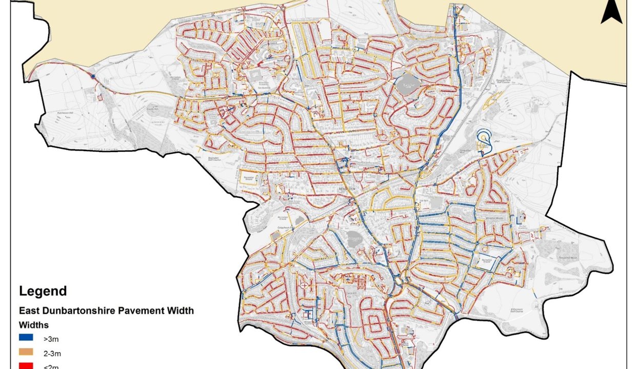
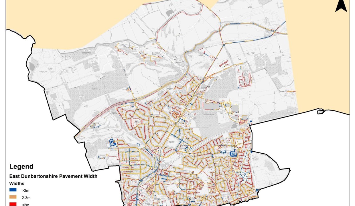
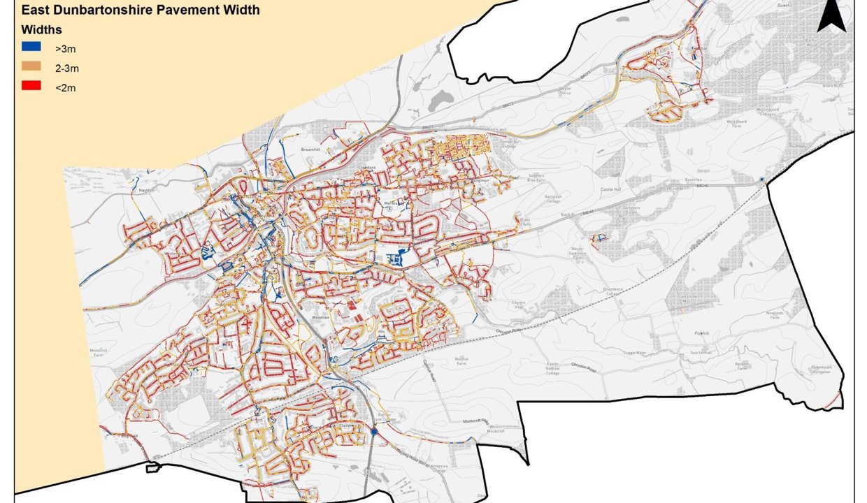
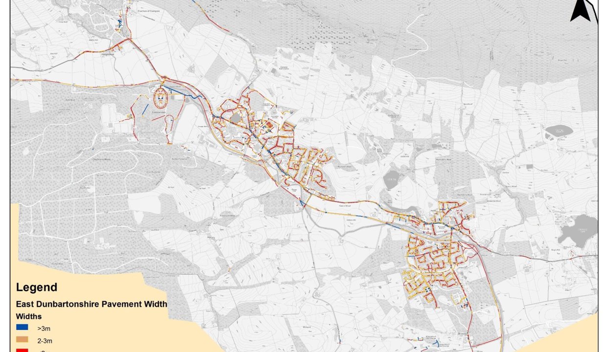
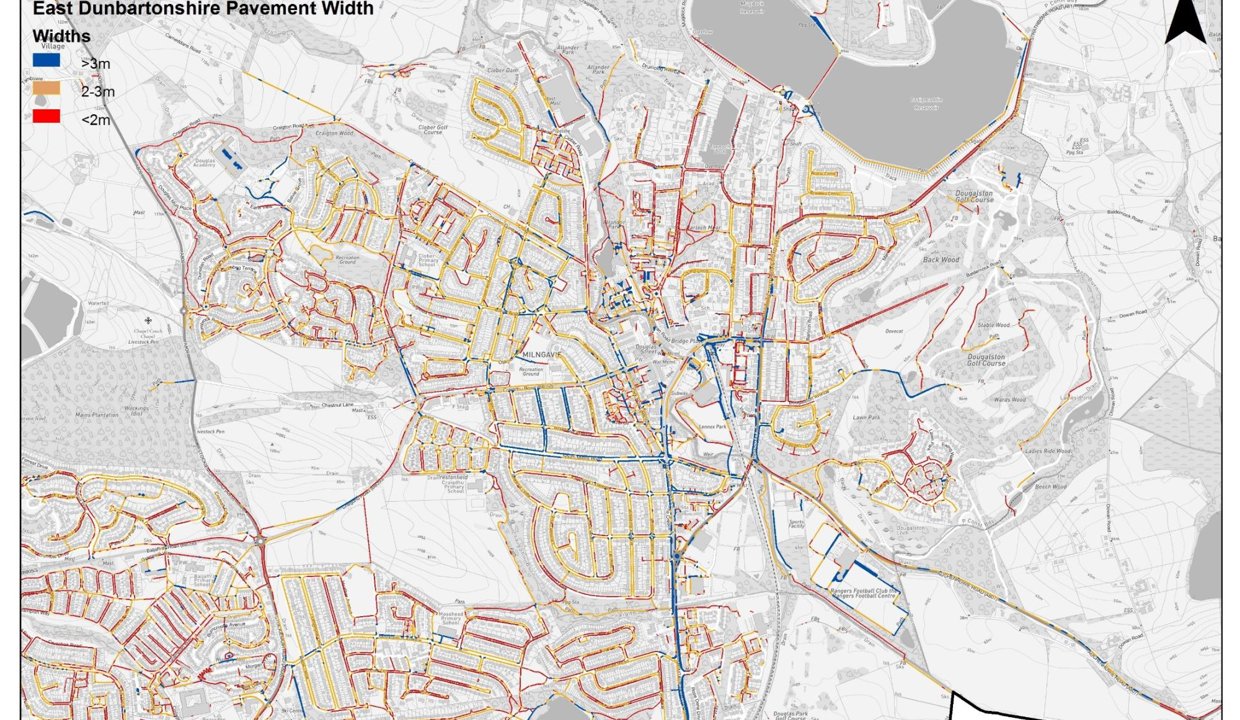
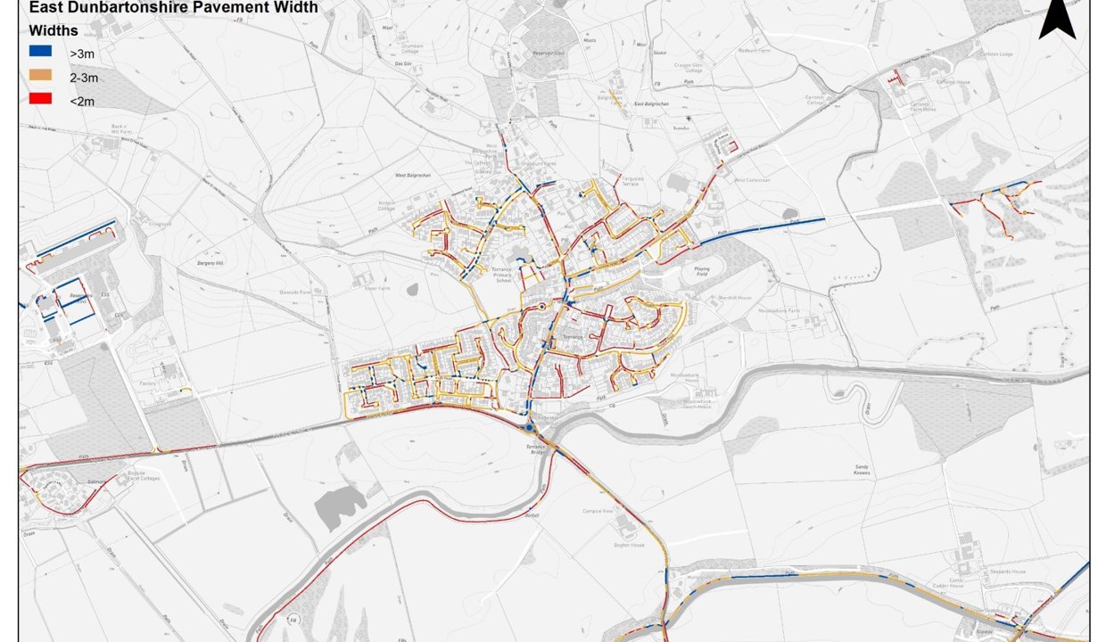
The widths of current footways in East Dunbartonshire have been mapped in a way that can identify areas which lack the required levels of accessibility to provide an environment where everyone can use active travel as a mode for everyday trips. On top of this, wider pavements increase perceptions of safety for walking and wheeling and safety is one of the three primary barriers to modal shift towards active travel in East Dunbartonshire. The maps for areas of East Dunbartonshire can be found at the end of this report.
Sustrans advocates for a minimum pavement width of two metres to ensure accessibility. However, in order to create safe, pleasant environments for walking and wheeling, wider pavements are preferable. Therefore, pavements widths of three metres is desirable and pavements with less than a two metre width, particularly where they form an important part of the footway network, connecting people to everyday places, require consideration in the upcoming Active Travel Strategy.
Conclusion
The network connectivity assessment has shown that East Dunbartonshire has an active travel network that is adequate for leisure trips, access to greenspace and access to some key trip generators. That said, the off-road and unlit nature of most paths mean those paths are mostly unused in hours of darkness. The regional connectivity section demonstrates the commitment to a regional network that has been made by the Council through its regional involvement in SPT and the Glasgow and Clyde Valley Green Network Partnership and that Glasgow City Council is working on a network that will meet the East Dunbartonshire Council boundary. With shifts in national policy and funding towards active travel, the upcoming Active Travel Strategy represents an opportunity to connect people to the everyday places they want to go through active travel infrastructure, allowing them to safely and confidently make healthy, sustainable transport choices.
Maps of Local Area
